The Foundation will be closed JUne 11–12 for a private event.
Leopold Center Details Here
Leopold Center Details Here


On Friday, May 20th, we hosted a free lecture at the Leopold Center by John Attig to share an overview of the geology of the Wisconsin River. John and his collaborator Eric Carson – a professor of geology with University of Wisconsin-Extension and a research geologist at the Wisconsin Geological and Natural History Survey – agreed to summarize their talk here for our blog readers. Enjoy!
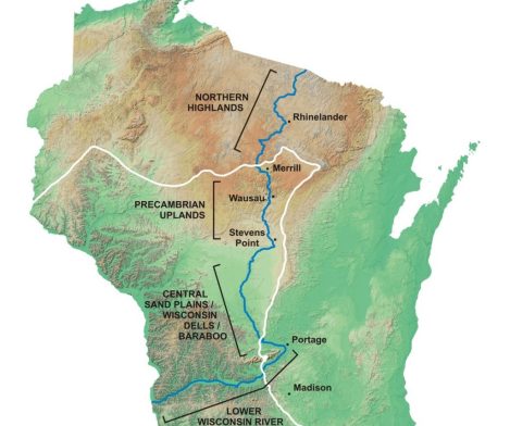
The Wisconsin River flows southward from near the Wisconsin/Michigan border in north-central Wisconsin to the area of the Baraboo Hills, and then westward to its junction with the Mississippi River near Prairie Du Chien. The characteristics of the landscape through which the river flows, and the geologic history those landscapes reveal, define four distinct segments of the river. These are Northern Highland, Precambrian upland, Central Sand Plain, and lower Wisconsin River segments.
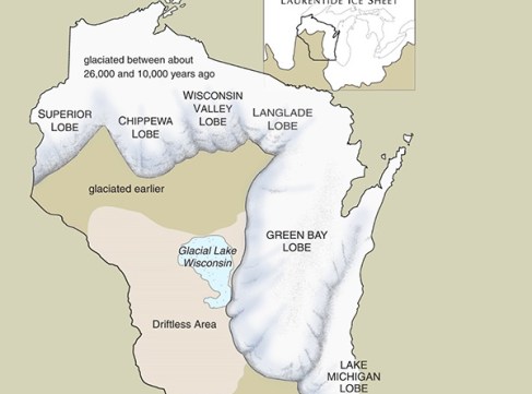
The northernmost part of the river flows through Wisconsin’s iconic Northern Highlands, an area best known for its abundant lakes and wetlands surrounded by forested hills and extensive sand plains. This is the area glaciated by the Wisconsin Valley Lobe of the Laurentide Ice Sheet, a lobe of ice that advanced out of the Superior basin into the northern part of the Wisconsin River Valley. In this area the Wisconsin River established its course as the last of the buried ice remnant from the advance and recession of the Wisconsin Valley Lobe melted. This melting of buried ice was delayed for thousands of years after the recession of the Wisconsin Valley Lobe by permafrost. Parts of the course of the river likely became established as ice-walled rivers draining this frozen landscape. By about 14,000 years ago climate warmed sufficiently for permafrost to thaw and for buried ice to melt. The modern course of the Wisconsin River was established in the Highlands during this time.
South of the Highland segment the river flows across an upland composed predominantly of Precambrian rock. Little is known about the geologic history of this part of the river. Clearly the general shape of the Wisconsin Valley existed prior to the most recent glaciations because the valley controlled the shape of the margin of the advancing ice. It is likely that the course of the Wisconsin River across these uplands has been much the same for at least several hundred thousand years.

The Central Sand Plains part of the river flows across an extensive, nearly flat, sand plain. Much of this sand plain was deposited in the main basin and the Lewiston basin of glacial Lake Wisconsin. Glacial Lake Wisconsin was about the size of modern Great Salt Lake. The Leopold Shack is on the sandplain in the southern part of the Lewiston basin. Glacial Lake Wisconsin formed when ice of the Green Bay Lobe advanced onto the eastern end of the Baraboo Hills damming the Wisconsin River. The area of the central sand plain flooded until the level of the water was high enough to drain out an outlet to the northwest. Eventually the ice dam at the east end of the Baraboo Hills failed resulting in a catastrophic flood as glacial Lake Wisconsin drained in a very short period of time. This flood resulted in the erosion of the gorges that are the Wisconsin Dells. The modern course of the Wisconsin River could not have become established across the Central Sand Plain until after glacial Lake Wisconsin drained, around 18,000 years ago.

The lower Wisconsin River is best known for its picturesque vertical bedrock bluffs and numerous sandbars. For several decades it has been thought that parts of a high terrace along this segment of the river are remnant from a time when a glacier flowing from the northwest blocked the western end of the valley and caused the river to temporarily flow to the east. Recent evaluation of the landscape of the lower Wisconsin valley, and broader areas of Wisconsin and the Midwest, indicate the lower Wisconsin valley was formed as a part of river system that drained eastward to the St. Lawrence River, and subsequently experienced a reversal of flow to become the modern westward flowing lower Wisconsin River.
The Aldo Leopold Foundation was founded in 1982 with a mission to foster the land ethic through the legacy of Aldo Leopold, awakening an ecological conscience in people throughout the world.


